

Construction Updates
What You Need to Know
Whether you live, work, or travel near the bridge, we want you to know what to expect and what we’re doing to minimize disruptions.
- Work Hours: Construction activity will typically occur Monday through Saturday during daylight hours within a 12-hour window.
- Noise & Vibration Monitoring: Monitoring equipment is being used in nearby communities to provide real-time feedback to the construction team and help minimize disruption.
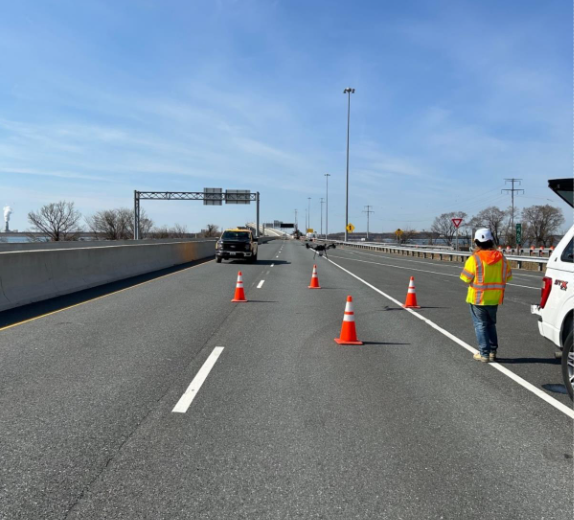
- You Will See: Large equipment, construction crews, and increased activity on land and in the water.
- You May Hear: Noise typical of large construction projects, and loud, repetitive hammering sounds from pile driving.
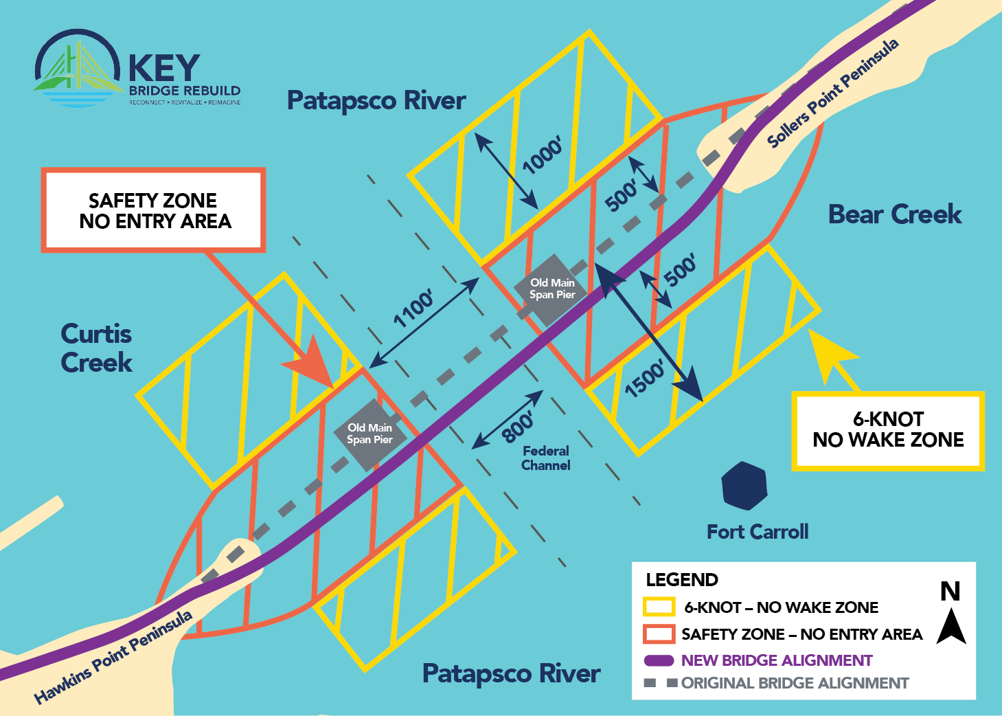
Safety Guidelines for Waterway Users
To support safe navigation during construction, all waterway users should follow these safety guidelines:
- Obey Safety Zones and No Entry Areas: Follow all Safety Zone-No Entry Area’s marked as restricted areas.
- Federal Navigation Channel Remains Open: Please take precautions with larger ships.
- Slow Down Near Construction Zones: Maintain speeds of 6-knots or less to minimize wake when transiting adjacent to construction equipment and listen for important communication from project vessels via VHF FM marine radio channels 16 and/or 13.
- Stay Informed: Check the USCG District 5 Local Notice to Mariners for real-time updates and navigation alerts.
Work Schedule and Activities
A look at the planned and ongoing work advancing the Key Bridge Rebuild.
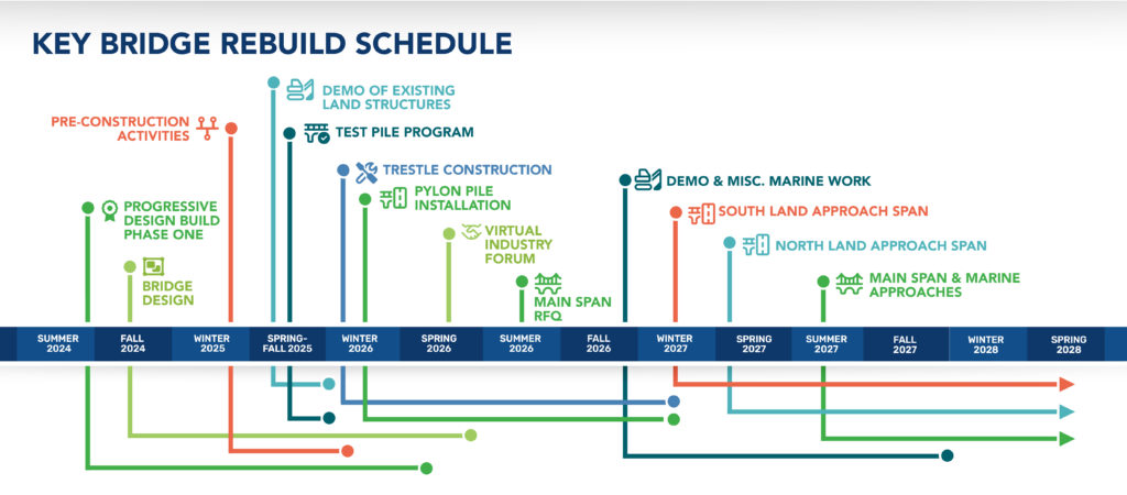
Key Bridge Rebuild Schedule
- Progressive Design Build Phase One: Summer 2024 thru Spring 2026
- Bridge Design: Fall 2024 thru Spring 2026
- Pre-Construction Activities: Winter 2025 thru Winter 2026
- Demo of Existing Land Structures: Spring/Fall 2025 thru Winter 2026
- Test Pile Program: Spring/Fall 2025 thru Winter 2026
- Trestle Construction: Winter 2026 thru Winter 2027
- Pylon Pile Installation: Winter 2026 thru Winter 2027
- Virtual Industry Forum: Spring 2026
- Main Span RFQ: Summer 2026
- Demo & Misc. Marine Work: Fall 2026 thru Fall 2027
- South Land Approach Span: Winter 2027 thru Spring 2028
- North Land Approach Span: Spring 2027 thru Spring 2028
- Main Span & Marine Approaches Summer 2027 thru Spring 2028
Ongoing Activities
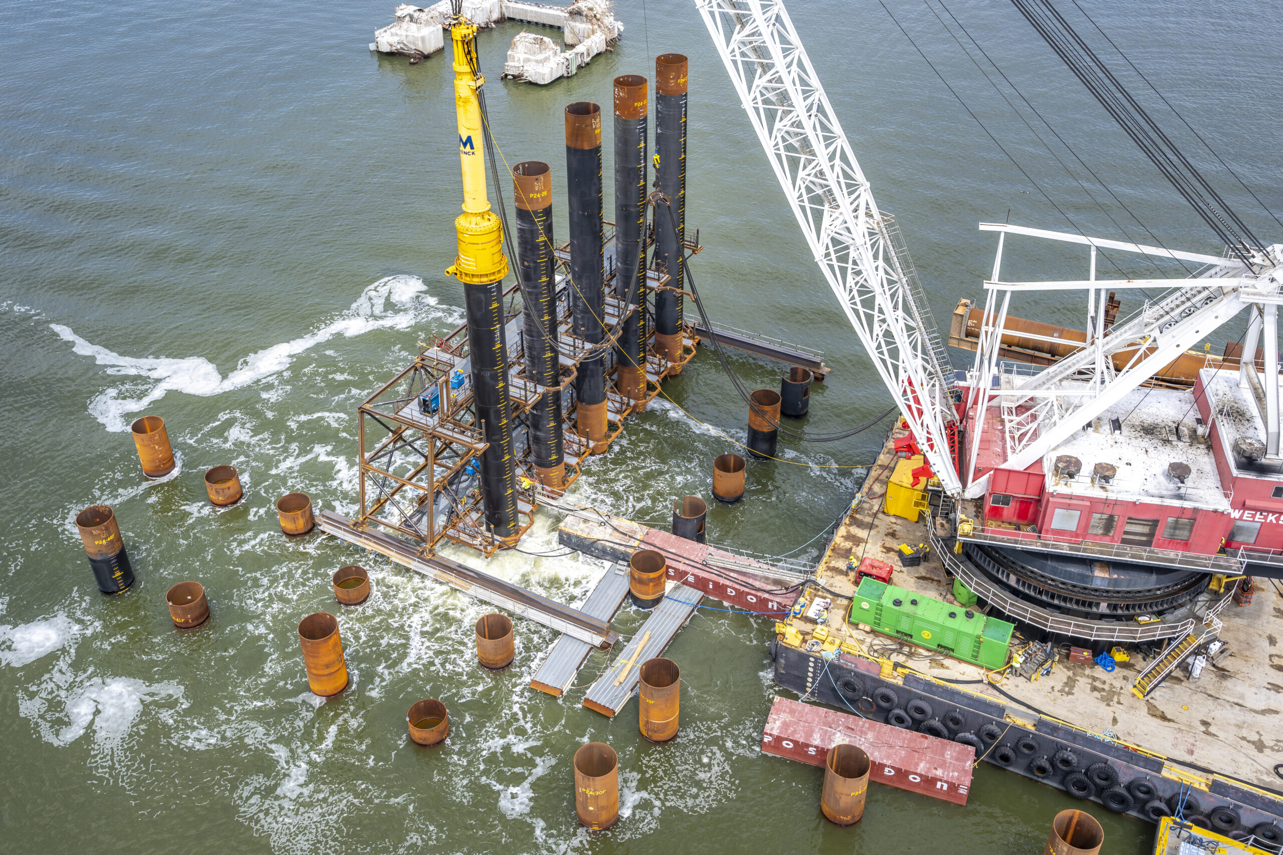
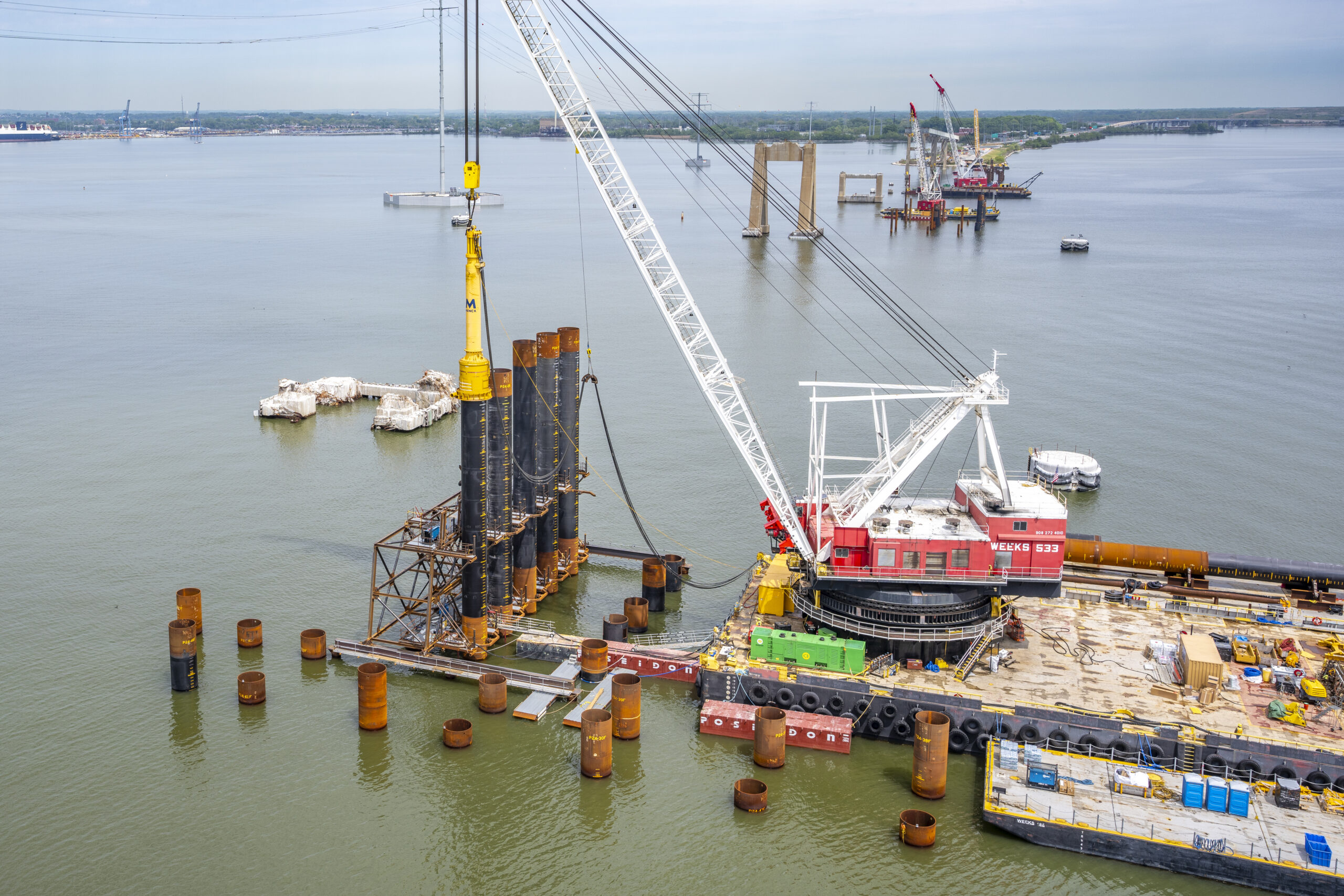
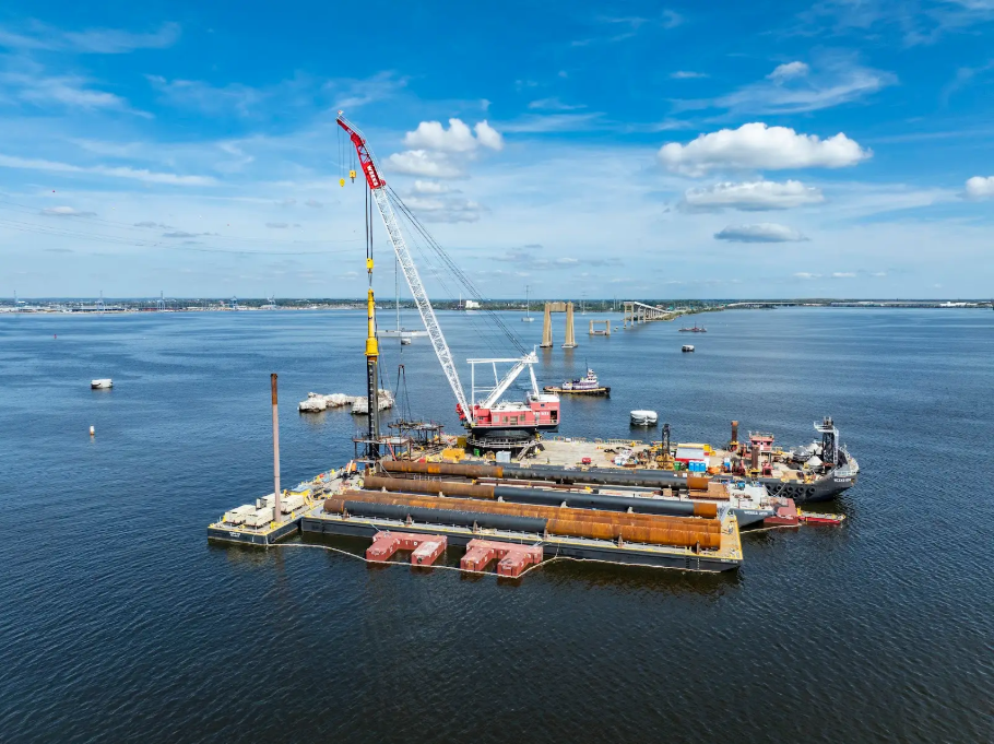
Permanent Foundation Piles Installation
- The team drove the first permanent foundation pile in December 2025, marking the beginning of the main span construction.
- Additional equipment has arrived on site including a second impact hammer, crane barges, and a pile-driving template. This equipment allows the team to place, vibrate, and impact up to seven permanent piles at once, which improves efficiency while maintaining a high level of accuracy, control, and safety.
Temporary Trestle Construction
- The construction of the temporary trestles began in December 2025 by separate crews on both the north and south side of the river.
- The team is welding piles, driving piles, and installing crane mats, allowing the team and equipment to begin accessing and working on the new bridge piers directly from the trestle.
- These platforms or trestles will allow for quick and safe drive-up access for crews, equipment, and materials from both peninsulas to the main pylons.
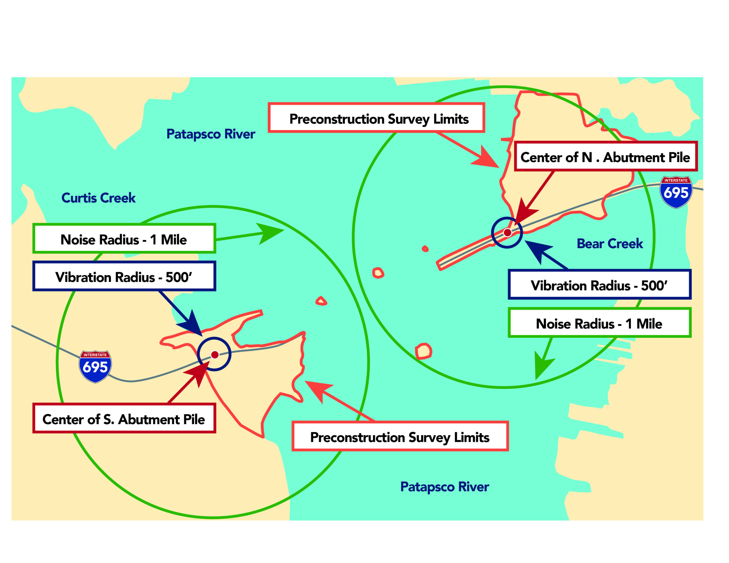
Noise and Vibration Monitoring
- Monitoring equipment was installed in nearby communities to record baseline noise and vibration levels before demolition, test pile installation, and full construction began.
- These baseline readings helped define normal everyday conditions in the area.
- Ongoing monitoring during construction allows the team to track changes in noise and vibration and respond as needed.
Completed Activities
Mechanical Land Demolition
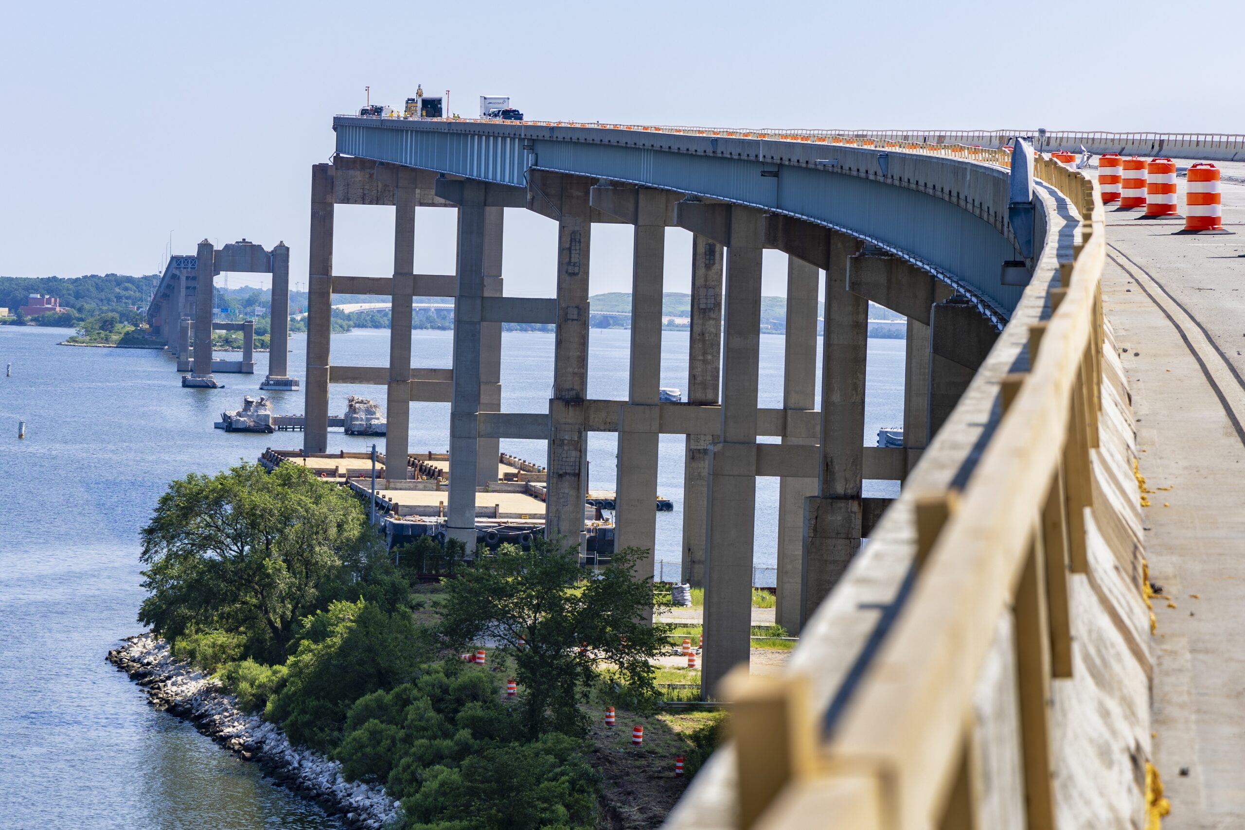
- Demolition of the existing bridges over land was completed in February 2026. Crews will remove the three bridge spans in the water on both the north and south sides later in the construction process.
- On land, the team removed 20,000 tons of concrete decking, concrete columns, and removed 160 steel girders on both the north and south sides of the bridge.
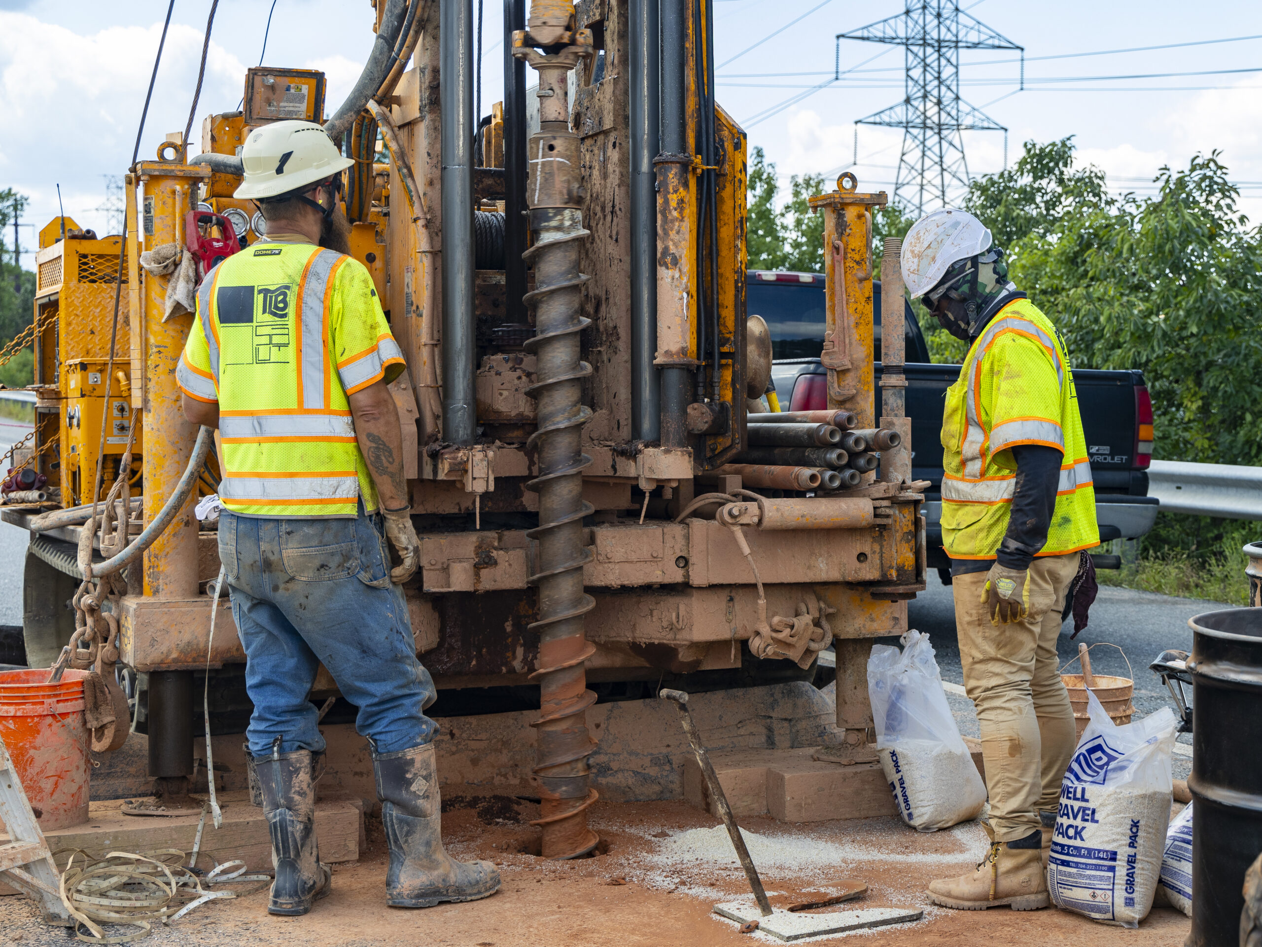
Test Pile Program
- The Test Pile Program began in September 2025 and was successfully completed in February 2026 and confirmed the strength and performance of the project’s foundation design, allowing the team to progress directly into driving permanent piles.
- The team drove six test piles at each of the main span piers to the north and south of the federal navigation channel. They installed a load frame and jacking system to simulate the forces the piles will experience once the bridge is built. A vertical and horizontal load test were performed on the piles and both tests were successful.
Completed Pre-Construction Activities

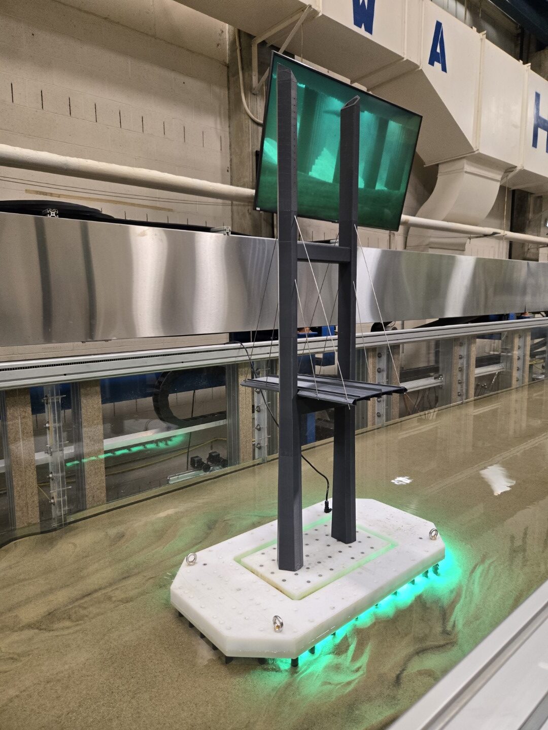
Wind Tunnel Testing
- Engineers simulated conditions to study how the bridge responds to various wind loads.
- The bridge’s cross section was tested based on wind and traffic patterns from the final design.
Surveying and Mapping
- Crews collected topographic data using drone flights, right-of-way boundary surveys and subsurface utility mapping to support detailed design work.
Scour Testing
- Specialists modeled water flow around the bridge’s foundation and support piles to assess impacts on the riverbed and ensure long-term structural stability.
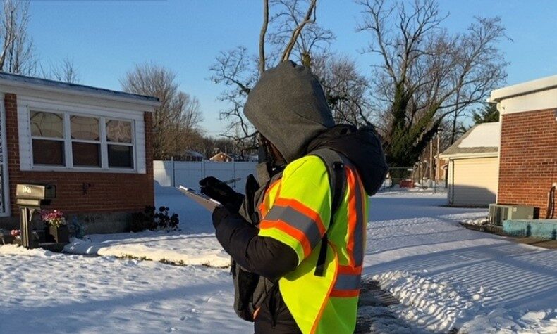
Property Inspections
- Teams completed 1,121 property inspections to document baseline conditions before major construction begins.
- Inspections covered properties within a 1-mile radius of the northernmost and southernmost pile-driving locations.
- Photo and video documentation during inspections captured pre-construction conditions of the properties.
Test Pile Fabrication
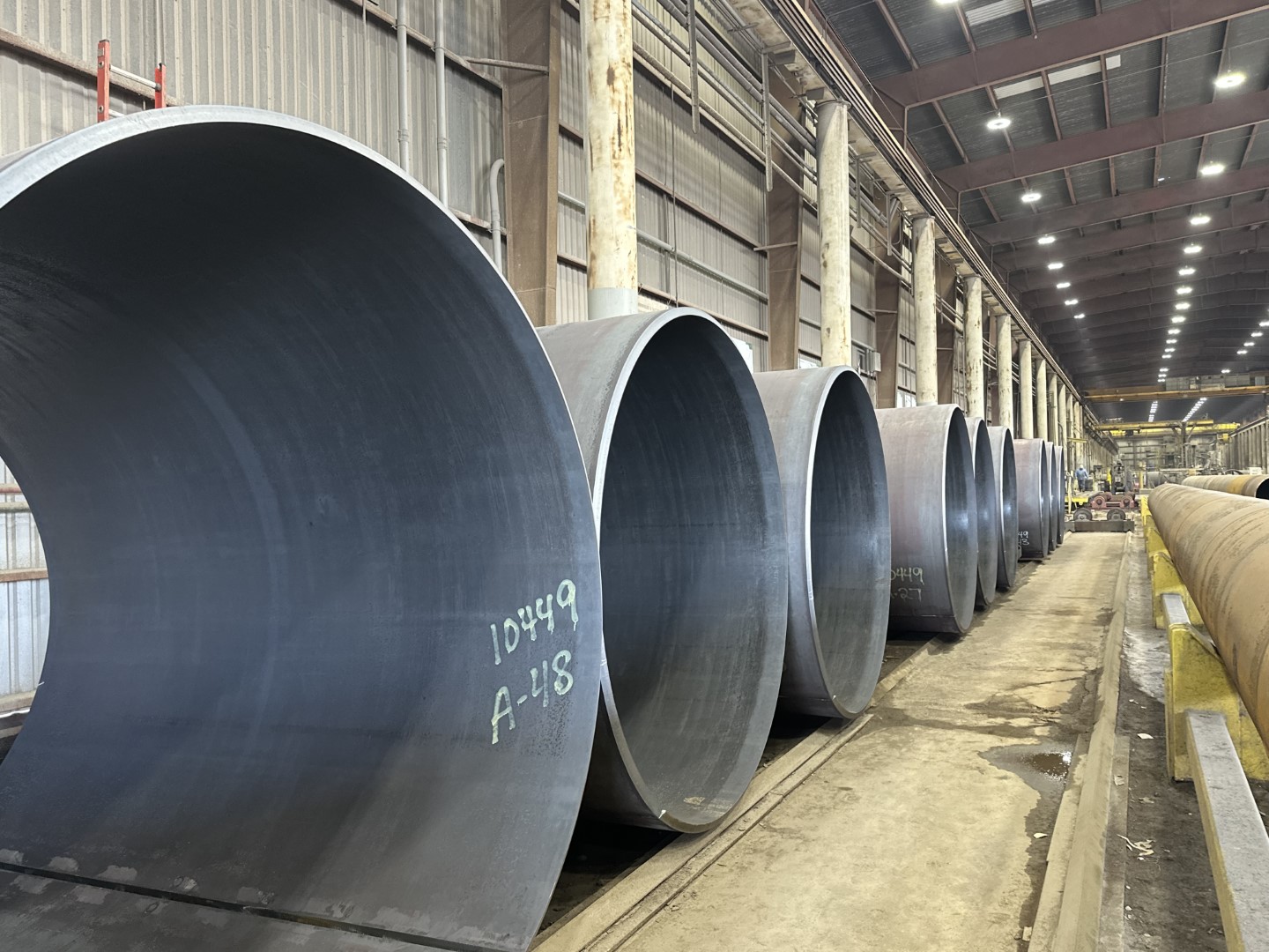
- Crews fabricated test piles and load test frames for the pile load testing program, which supports the design of the bridge’s main span.
- Each test pile was built piece by piece, with the finished piles measuring 8 feet wide and over 200 feet long.
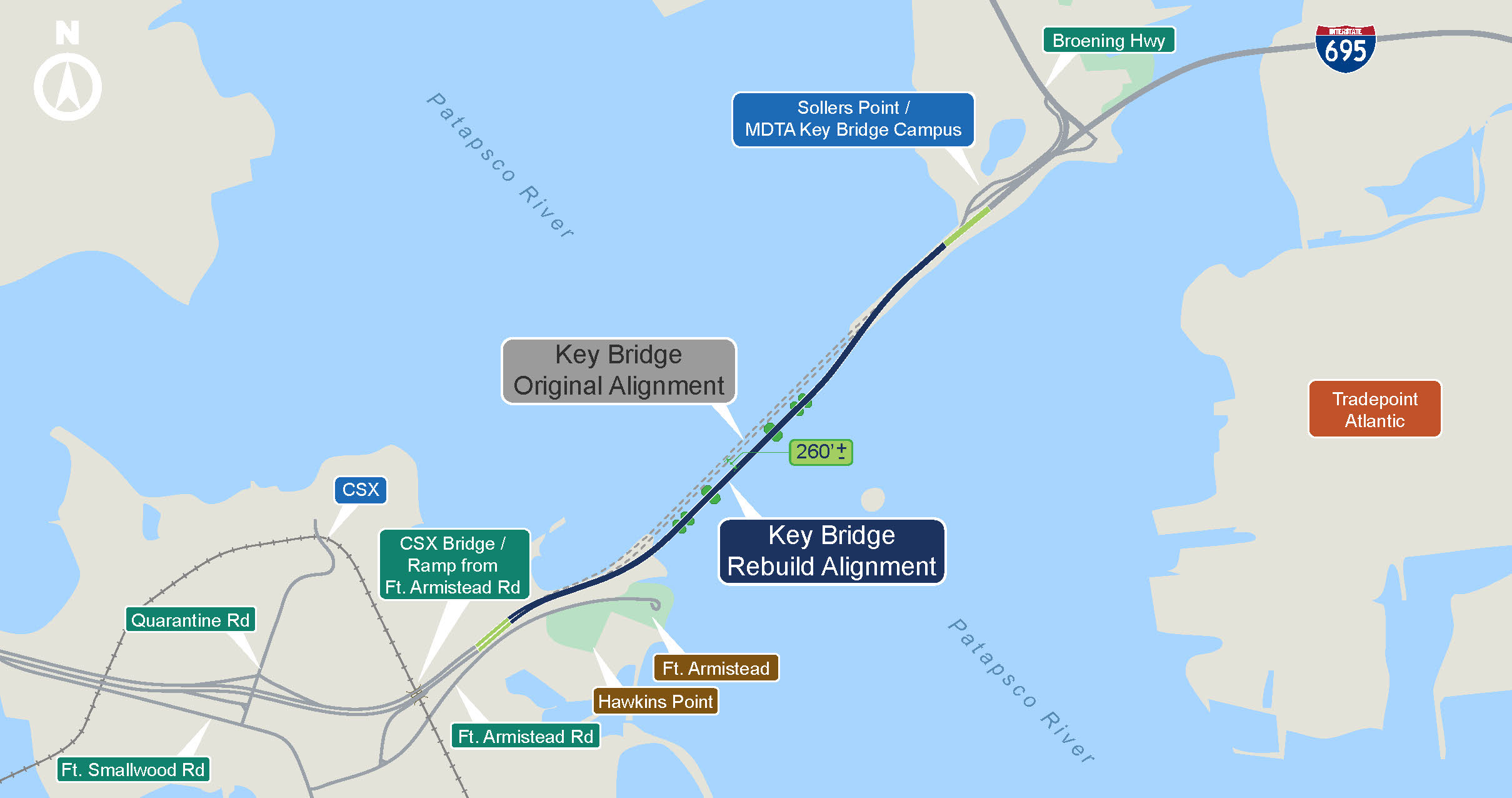
Bridge Alignment
- Based on months of field investigations and engineering analysis, the new bridge alignment was determined to be slightly east (downriver) of the original structure.
- The alignment remains entirely within MDTA’s existing right-of-way.
Geotechnical Investigations
- Engineers conducted extensive marine-based borings in the Patapsco River riverbed and land-based borings along the bridge alignment to evaluate soil conditions and support the pile and foundation design.
- Laboratory tests classified the soils found in the riverbed and on the north and south sides of the bridge.
- The geotechnical boring results identified the soil profile beneath the surface, helping guide the design of the bridge foundations.
Construction Related News
Progress Continues as Test Pile Program Set to Begin for Key Bridge Rebuild
Demolition Set to Begin as MDTA Shares Key Bridge Rebuild Update Press Release – June 26, 2025
Voluntary Pre-Construction Property Inspections (Jan-Feb 2025)
MDTA Announces Construction Management and Inspection Services Contracts Press Release – February 12, 2025
GEC Contract, Facebook Page Launch, Pre-Construction Activities Begin Press Release – January 8, 2025
Bridge Construction FAQ
Based on the latest estimates released in November 2025, the MDTA now anticipates the new bridge will open to traffic in late 2030. Recent pre-construction activities, updated datapoints, and design – not available in the immediate days following the bridge collapse – have been used to inform the MDTA on an updated estimated cost and schedule for the project. The MDTA remains committed to rebuilding the Key Bridge with safety, economic vitality, and sound stewardship of taxpayer dollars as top priorities, and will continue to provide updates as more detailed schedule information becomes available. Learn more
The new bridge will be Maryland’s first highway cable-stayed bridge, which will consist of two lanes in each direction and have a minimum vertical clearance of 230 feet to support larger vessels. It will be constructed according to the most advanced industry standards and best infrastructure design practices. Cable-stayed bridges have proven to be the most economical for bridges with similar span lengths and allow for a faster construction time compared to other complex bridge types. The maintenance costs of cable-stayed bridges are also less than those of other comparable bridge types.
There will be two 12-ft lanes with a 10-ft outside shoulder and a 4-ft insider shoulder in each direction, separated by a concrete median.
Pre-construction began in January 2025 and construction is expected to begin in late 2025 with production pile installation.
The State of Maryland continues to pursue the DALI’s owner and manager for all of the damages caused by their negligence and incompetence – including the cost to reconstruct the Francis Scott Key Bridge – so that the parties responsible for this tragedy pay for the damages they caused. The American Relief Act, 2025, provides that if any additional funds are required to build the new bridge beyond the compensation paid by the DALI, the federal government will provide that funding.
Yes, visit the Opportunities page on the Key Bridge Rebuild website for opportunities with the Contractor and upcoming bid opportunities.
While the demolition and rebuild process may have some impact, as noted above, the Federal Highway Administration (FHWA) determined that the replacement Key Bridge will have limited environmental impacts, as it stays within MDTA’s right-of-way and maintains the same four-lane capacity.
The MDTA collaborates closely with state and local partners to minimize impacts on the Patapsco River and surrounding communities. Boat traffic is limited to old main span piers, including the navigational channel and the 150-foot buffer areas on either side of the channel near the construction site. Fort Armistead Park and Bear Creek access will remain open through construction of the new bridge. Waterway users need to slow down and use caution while transitioning through the permissible areas. A 6-knot speed zone has been implemented by the Maryland Department of Natural Resources and extends 1,500 feet upstream of the old bridge and 1,500 feet downstream of the new bridge, excluding the navigation channel. The U.S. Coast Guard-enforced Temporary Safety Zones (TSZs) or Exclusion Zones are similar but defined by white buoys and based on active work. The TSZs will be in place for the duration of the demolition and rebuild processes.
- Environmental and Permitting Efforts: Coordinated with Federal and State partners to obtain all necessary permits
- Geotechnical Investigations: Extensive water-based borings of the Patapsco riverbed and land-based boring along the bridge alignment were completed to assess soil conditions and identify potential subsurface obstructions.
- Survey and Mapping: Collection of topographic data, right-of-way boundaries, and subsurface utility mapping to support detailed construction planning.
- Property Inspections: Completed 1,121 property inspections and documentation to establish baseline conditions ahead of major construction activities.
- Noise and Vibration Monitoring: Installation of monitoring equipment in surrounding communities to capture baseline noise and vibration data prior to the start of test piles and full construction.
- Wind Tunnel Testing: Modeling real-world wind conditions to study the structures response in order to fine-tune the design.
- Scour Testing: Modeling how water moves around the foundation and piles to understand impacts to the riverbed.
- Test Pile Program: 8-foot diameter and 200+-foot long American-made steel test piles have started to be driven into the Patapsco River in support of the reconstruction efforts.
Demolition of the remaining Key Bridge structures—both on land and over water—will occur in phases beginning in summer 2025 and will take several months to complete. Heavy machinery will be used throughout the process, which will not involve controlled detonations.
Work will begin with the removal of the deck, barriers, and parapets over the river from both Hawkins Point and Sollers Point. Crews will then remove the deck, barriers, parapets, girders, and piers on the landside approaches, down to just below ground level, at both locations. The final step will be the removal of the original north and south abutments.
Test piling serves as proof of concept to determine how strong and stable foundation supports (piles) are as they interface with the native soil, to make sure they can safely hold up the structure. Periodic test pile driving began in October 2025 and will continue through early Winter 2025/26. The results will guide the final design and construction of the main span foundations.
The MDTA has installed noise and vibration monitors to collect data on the construction activities. Bubble curtains around the test piles have also been installed to reduce noise and vibration impacts as well as deter fish and other wildlife from entering the construction zone.
A construction trestle is a temporary support structure used in various construction projects, particularly in bridge and elevated roadway construction. It typically consists of a framework made from materials such as steel or timber, designed to bear significant loads. In the case of the Key Bridge, the trestle will look similar to a conventional roadway bridge that is close to the Patapsco waterline and will be used exclusively by construction personnel.
The primary function of a construction trestle is to provide a stable platform for workers and equipment and to support the weight of structural components during assembly. This method ensures that the construction process can proceed safely and efficiently.
Once the bridge is reconstructed, the trestle is dismantled and removed from the site. This temporary support system is crucial for maintaining the integrity and safety of the construction process.
The trestle will be constructed within the limits of disturbance that were identified in the original environmental approval.
Sign Up for Alerts
I would like to opt-in to receive project related emails and/or text messages from the Key Bridge Rebuild team.